Chapter 11 -- Hurricanes
| Hurricane Hurricane Center | Hurricanes from Book | Long Island Severe Weather Guide |
TRACK HURRICANES -
National Hurricane Center - http://www.nhc.noaa.gov/
NYC/LI National Weather Service Page - http://www.weather.gov/okx/tropical
http://www.ral.ucar.edu/hurricanes/realtime/current/
http://preview.weather.gov/hti/#/local-forecast/
VVERY IMPORTANT!!!!!!* TEST 4 - WEDNESDAY MAY 6TH - IF YOU HAVE ANY QUESTION ON THE CHAPTERS PLEASE EMAIL ME -- PLEASE REACH OUT..
TEST 4 - WEDNESDAY MAY 6TH -
**** THE EXAM IS DURING YOUR CLASS TIME AND CLASS TIME ONLY -
VERY IMPORTANT!!!!!!*****If you miss an exam - your final exam grade will replace the missed exam!!!!!
TEST 4 - WEDNESDAY MAY 6TH -
VERY IMPORTANT!!!!!!*****If you miss an exam - your final exam grade will replace the missed exam!!!!!
Tropical Weather -https://www.weather.gov/jetstream/tropics_intro
The vast majority of hurricane deaths and damage are caused by relatively infrequent, yet powerful storms.
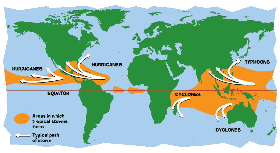
Most hurricanes form between the latitudes of 5° and 20° over all tropical
oceans except the South Atlantic and eastern South Pacific. The North Pacific
has the greatest number of storms, averaging 20 per year. In the western Pacific,
hurricanes are called typhoons, and in the Indian Ocean, they are referred to
as cyclones.
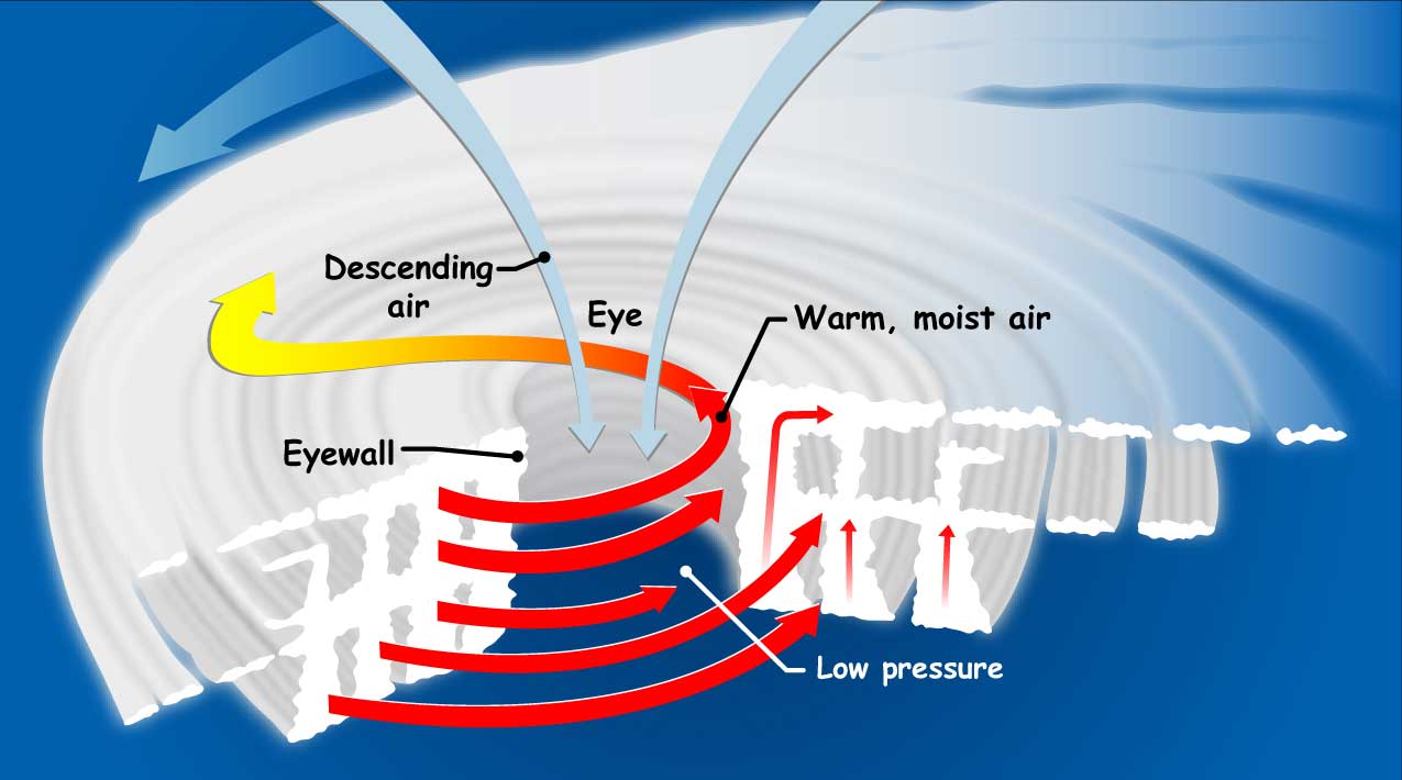
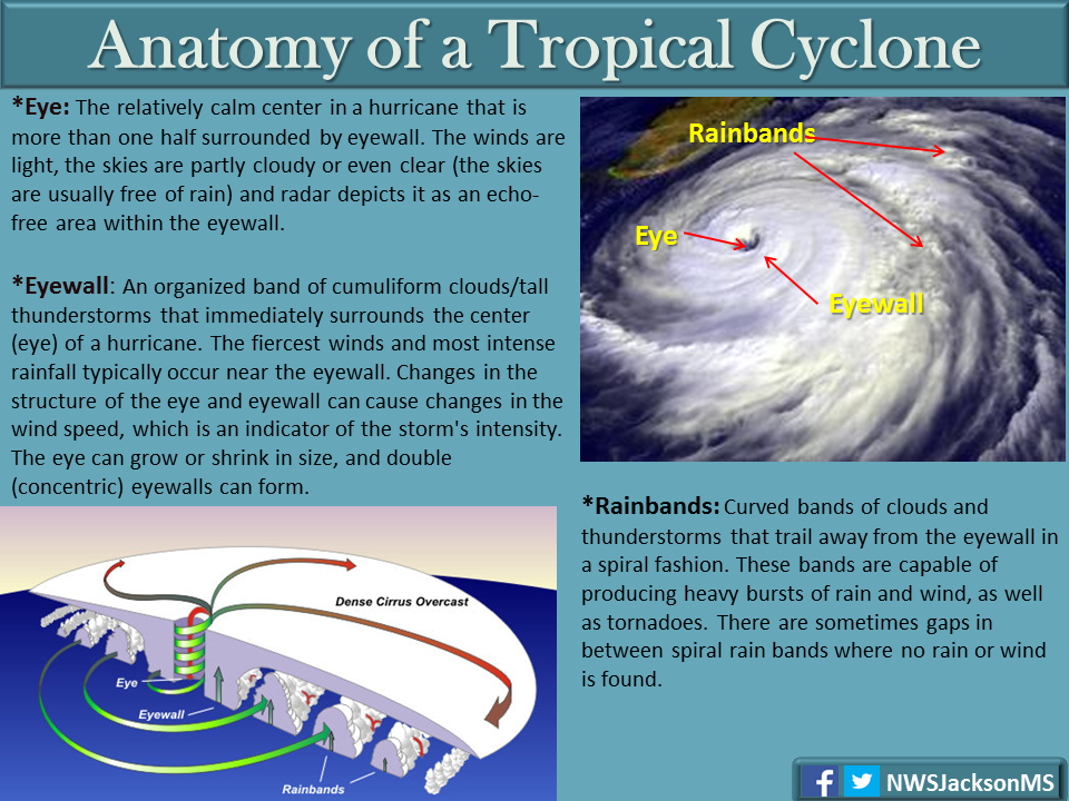
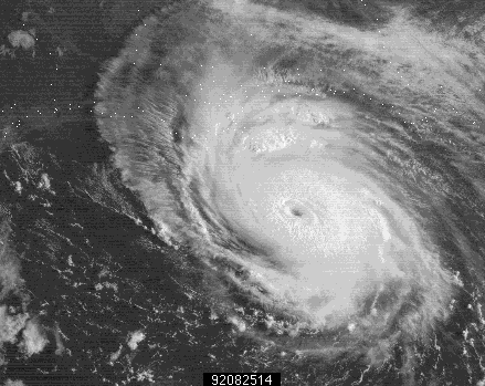
A steep pressure gradient generates the rapid, inward spiraling winds of a hurricane. As the warm, moist air approaches the core of the storm, it turns upward and ascends in a ring of cumulonimbus towers and forms a doughnut-shaped wall called the eye wall. At the very center of the storm, called the eye, the air gradually descends, precipitation ceases, and winds subside.
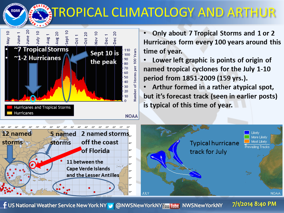
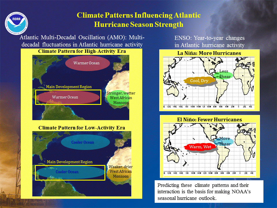
A hurricane is a heat engine fueled by the latent heat liberated when huge quantities of water vapor condense. They develop most often in late summer when ocean waters have reached temperatures of 27°C (80°F) or higher and are thus able to provide the necessary heat and moisture to the air. The initial stage of a tropical storm's life cycle, called a tropical disturbance, is a disorganized array of clouds that exhibits a weak pressure gradient and little or no rotation. Tropical disturbances that produce many of the strongest hurricanes that enter the western North Atlantic and threaten North America often begin as large undulations or ripples in the trade winds known as easterly waves. Atlantic Hurricane/Tropical season June 1st to November 30th
FOCUS ON HOW AND WHERE HURRICANES FORM...
HOW DOES A LOW PRESSURE SYSTEM BECOME A HURRICANE? WHAT IS A TROPICAL DEPRESSION? TROPICAL STORM? HURRICANE? MAJOR HURRICANE? WHEN IS HURRICANE SEASON. DOES LONG ISLAND GET HIT BY HURRICANES? IF SO? WHEN? WHEN WAS THE LAST HURRICANE TO CROSS LONG ISLAND? UNDERSTAND WHAT DAMAGE HURRICANES CAN CAUSE. WHAT IS STORM SURGE? WHAT ARE WIND SPEED IMPORTANT WITH TROPICAL SYSTEMS? WHAT IS THE SAFFIR-SIMPSON SCALE?
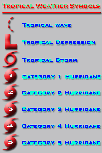
TROPICAL ORDER --
TROPICAL WAVE - TROPICAL DEPRESSION - TROPICAL STORM - HURRICANE
AT 39 MPH / 34 KNOTS - TROPICAL STORM HAS A NAME ASSIGNED TO IT.
HURRICANE BASICS..
Formation of a Hurricane Video
PROFESSOR HOFFMAN CHAPTER 11 PART 1 VIDEO
Tropical Structure - https://www.weather.gov/jetstream/tc_structure


Chapter 11 Video -- Part 2 from Professor Hoffman
Tropical cyclones are classified into four types, based on their wind speeds. These are terms commonly used by forecasters and you'll encounter them throughout this CHAPTER:
Once a tropical storm forms, NHC gives it a name from the list for the current year. (Click here for a link to the current list of tropical cyclone names.) Each list is reused every six years, although names of hurricanes that have resulted in substantial damage or death are retired. The letters Q, U, X, Y, and Z are not included in the Atlantic list because of the scarcity of names beginning with those letters. If more than 21 named tropical cyclones occur in the Atlantic basin in a season, additional storms are named from the Greek alphabet: Alpha, Beta, Gamma, Delta, and so on.
Each list alternates between male and female names. Names utilized are English, Spanish, or French, reflecting the diversity of communities throughout North America, Central America, and the Caribbean that are impacted by these cyclones.
Tropical Depression:
A tropical cyclone in which the maximum sustained surface wind speed (using
the U.S. 1-minute average) is 33 kt (38 mph or 62 km/hr) or less.
| Miles per hour | Knots | Kilometer/hr or Kph |
| Under 39 mph | Under 33 knots | Under 62 Km/hr |
Tropical Storm:
A tropical cyclone in which the maximum sustained surface wind speed (using
the U.S. 1-minute average) ranges from 34 kt (39 mph or 63 km/hr) to 63 kt (73
mph or 118 km/hr).
| Miles per hour | Knots | Kilometer/hr or Kph |
| 39-73 mph | 34-63 knots | 63- 118 Km/hr |
Hurricane / Typhoon:
A tropical cyclone in which the maximum sustained surface wind (using the U.S.
1-minute average) is 64 kt (74 mph or 119 km/hr) or more. The term hurricane
is used for Northern Hemisphere tropical cyclones east of the International
Dateline to the Greenwich Meridian. The term typhoon is used for Pacific tropical
cyclones north of the Equator west of the International Dateline.
| Miles per hour | Knots | Kilometer/hr or Kph |
| 74 mph or greater | 64 knots or greater | 119 Km/hr or greater |
Tropical Storm Names - https://www.weather.gov/jetstream/tc_names
TEST 4 - WEDNESDAY MAY 7TH-
FOCUS ON HOW AND WHERE HURRICANES FORM...
HOW DOES A LOW PRESSURE SYSTEM BECOME A HURRICANE? WHAT IS A TROPICAL DEPRESSION? TROPICAL STORM? HURRICANE? MAJOR HURRICANE? WHEN IS HURRICANE SEASON. DOES LONG ISLAND GET HIT BY HURRICANES? IF SO? WHEN? WHEN WAS THE LAST HURRICANE TO CROSS LONG ISLAND? UNDERSTAND WHAT DAMAGE HURRICANES CAN CAUSE. WHAT IS STORM SURGE? WHAT ARE WIND SPEED IMPORTANT WITH TROPICAL SYSTEMS? WHAT IS THE SAFFIR-SIMPSON SCALE?
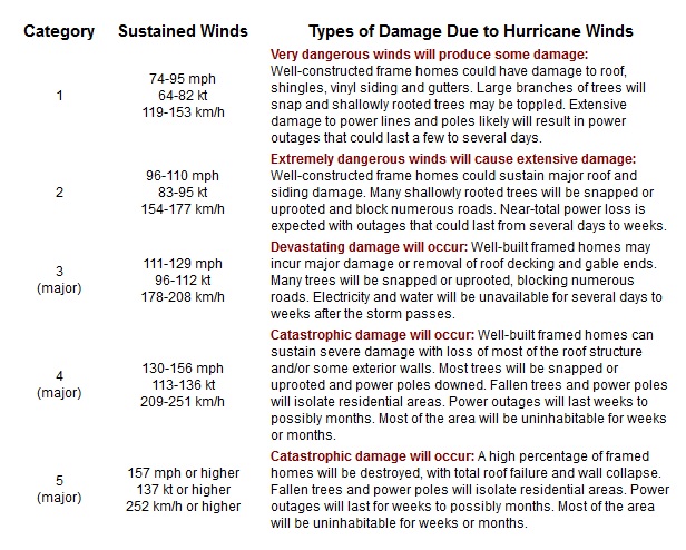
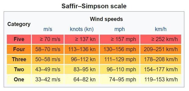
SAFFIR - SIMPSON SCALE BELOW--------
Minor
Modification to Saffir-Simpson Hurricane Wind Scale For the 2012 Hurricane Season
Each year, only a few tropical disturbances develop into full-fledged hurricanes
that require minimum wind speeds of 119 kilometers per hour. When a cyclone's
strongest winds do not exceed 61 kilometers per hour, it is called a tropical
depression. When winds are between 61 and 119 kilometers per hour, the cyclone
is termed a tropical storm. Hurricanes diminish in intensity whenever they (1)
move over ocean waters that cannot supply warm, moist tropical air, (2) move
onto land, or (3) reach a location where large-scale flow aloft is unfavorable.
Tropical Storm Names - https://www.weather.gov/jetstream/tc_names
 |
VERY IMPORTANT----
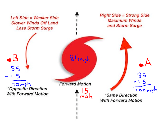
The Right Side of the Storm As a general rule of thumb, the hurricane's right side (relative to the direction it is travelling) is the most dangerous part of the storm because of the additive effect of the hurricane wind speed and speed of the larger atmospheric flow (the steering winds). The increased winds on the right side increase the storm surge described in the Hazards section of this module. Tornadoes are also more common here.Looking at the figure above, pretend you are standing behind the hurricane with your back to the steering flow. In this case, the right side is the eastern section of the hurricane. (If it were travelling east to west, the right side would be the north section.) The winds around the hurricane's eye are moving in a counterclockwise fashion. At Point A, the hurricane winds are nearly in line with the steering wind, adding to the strength of the winds. For example, if the steering currents are 15 mph and the average hurricane winds are 85 mph, the wind speed would be 100 mph at Point A. On the other hand, the winds at Point B are moving opposite those of the steering wind and therefore slow to 70 mph (85 - 15 mph).
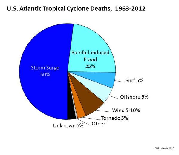
Although damage caused by a hurricane depends on several factors, including the size and population density of the area affected and the near-shore bottom configuration, the most significant factor is the strength of the storm itself. The Saffir-Simpson scale ranks the relative intensities of hurricanes. A 5 on the scale represents the worst storm possible, and a 1 is the least severe. Damage caused by hurricanes can be divided into three classes: (1) storm surge, which is most intense on the right side of the eye where winds are blowing toward the shore, occurs when a dome of water 65 to 80 kilometers (40 to 50 miles) wide sweeps across the coast near the point where the eye makes landfall, (2) wind damage, and (3) inland freshwater flooding, which is caused by torrential rains that accompany most hurricanes.
https://www.youtube.com/watch?v=Yh0pkZcDvqs
important - watch video below
Storm Surge Animation


Storm Surge:
http://www.stormsurge.noaa.gov/overview.html
What is storm surge?
Storm surges are frequently the most devastating element of a hurricane. As
a hurricane’s winds spiral around and around the storm, they push water
into a mound at the storm’s center. This mound of water becomes dangerous
when the storm reaches land because it causes flooding along the coast. The
water piles up, unable to escape anywhere but on land as the storm carries it
landward. A hurricane will cause more storm surge in areas where the ocean floor
slopes gradually. This causes major flooding.
http://www.nhc.noaa.gov/surge/
As you watch the storm-surge animations, notice the effect that the physical
geography of each coastline has on storm surge. Also, note the waves on top
of the ocean's surface. Wind, waves, and sea-level rise all contribute to storm-surge
damage.
Storm Surge Maps http://www2.sunysuffolk.edu/mandias/38hurricane/nys_storm_surge_zones.pdf
NOAA's SLOSH (Sea, Lake, and Overland Surge from Hurricanes) storm surge model.
http://www.wunderground.com/hurricane/MidAtlSurge.asp
North Atlantic hurricanes develop in the trade winds, which generally move these storms from east to west. Today, because of early warning systems that help detect and track hurricanes, the number of deaths associated with these violent storms have been greatly reduced. Because the tropical and subtropical regions that spawn hurricanes consist of enormous areas of open oceans, meteorological data from these vast regions are provided primarily by satellites. Other important sources of hurricane information are aircraft reconnaissance, radar, and remote, floating instruments called data buoys. Using data from the observational tools, meteorologists can issue an announcement, called a hurricane watch, aimed at specific coastal areas threatened by a hurricane, generally within 36 hours. By contrast, a hurricane warning is issued when sustained winds of 119 kilometers per hour or higher are expected within a specified coastal area in 24 hours or less. Two important factors in the watch-and-warning decision process are (1) adequate lead time and (2) attempting to keep overwarning at a minimum.
Profile of a Hurricane
whirling tropical cyclone
wind speeds exceeding 200 mph
extreme low pressure
most form between latitude 5 and 20 degrees
warm, moist air rushes inward, turns upward and ascends in a ring of cumulonimbus
clouds
eye - center of the storm
storm surge
FOCUS ON HOW AND WHERE HURRICANES FORM...
HOW DOES A LOW PRESSURE SYSTEM BECOME A HURRICANE? WHAT IS A TROPICAL DEPRESSION? TROPICAL STORM? HURRICANE? MAJOR HURRICANE? WHEN IS HURRICANE SEASON. DOES LONG ISLAND GET HIT BY HURRICANES? IF SO? WHEN? WHEN WAS THE LAST HURRICANE TO CROSS LONG ISLAND? UNDERSTAND WHAT DAMAGE HURRICANES CAN CAUSE. WHAT IS STORM SURGE? WHAT ARE WIND SPEED IMPORTANT WITH TROPICAL SYSTEMS? WHAT IS THE SAFFIR-SIMPSON SCALE? WHY IS THE RIGHT SIDE OF THE STORM DANGEROUS?
REVIEW FOR CHAPTER 9 -10 AND 11 EXAM 4
Hurricane Formation and Decay--------
develop most often in late summer when ocean waters have reached higher temperatures
(>27 C) OR 80 DEGREES F. June 1st to November 30th
development not well understood - starts with smaller tropical cyclone
diminishes when it moves over cooler ocean water or land
Detection and Tracking
satellites
aircraft reconnaissance
radar
data buoys positioned along east coast and Gulf of Mexico
There are many websites where you can find background information on hurricanes. You'll want to learn about how hurricanes form, which means learning about global wind patterns, and areas of high and low air pressure, among other things. The following web sites are good places to start: