Chapter 10 -- Thunderstorms and Tornadoes
| Thunderstorms | Thunderstorms2 from Book | Long Island Severe Weather Guide |
| Archive
of Significant Weather Events in the Tri-State Area Automated Climate Data, Local Forecasts, Marine Forecasts & Tide Reports are also available 24 hours a day from your local NWS Office at 631-924-0517. |
VERY IMPORTANT!!!!!!* TEST 4 -TEST 4 - WEDNESDAY MAY 6TH - -- IF YOU HAVE ANY QUESTION ON THE CHAPTERS PLEASE EMAIL ME -- PLEASE REACH OUT..
TEST 4 - WEDNESDAY MAY 6TH ----Chapter 9, 10 and 11
**** THE EXAM IS DURING YOUR CLASS TIME AND CLASS TIME ONLY -
VERY IMPORTANT!!!!!!*****If you miss an exam - your final exam grade will replace the missed exam!!!!!
TEST 4 - WEDNESDAY MAY 6TH -
VERY IMPORTANT!!!!!!*****If you miss an exam - your final exam grade will replace the missed exam!!!!!
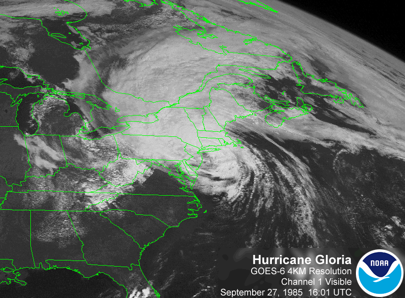
Although tornadoes and hurricanes are, in fact, cyclones, the vast majority
of cyclones are not hurricanes or tornadoes. The term "cyclone" simply
refers to the circulation around any low-pressure center, no matter how large
or intense it is. Thunderstorms, storms containing lightning and thunder, are
related in some manner to tornadoes, hurricanes, and midlatitude cyclones.
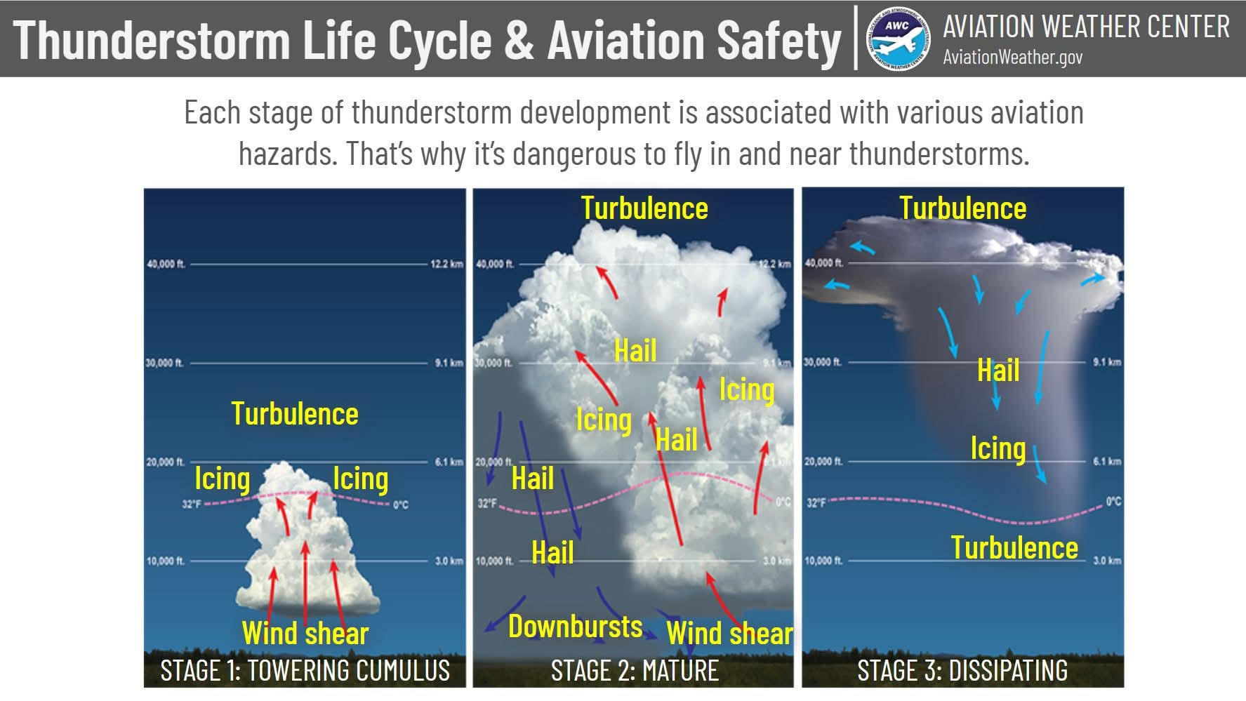
Dynamic thermal instability occurs during the development of thunderstorms, which form when warm, humid air rises in an unstable environment. A number of mechanisms, such as unequal heating of Earth's surface or lifting of warm air along a front or mountain slope, can trigger the upward air movement needed to create thunderstorm-producing cumulonimbus clouds. Severe thunderstorms produce high winds, damaging hail, flash floods, and tornadoes.
What Are Thunderstorms?
-storm containing lightning and thunder
-thunderstorms occur when warm, humid air rises in an unstable environment
-instability enhanced by high surface temps (afternoon, early evening)
-strong up and down movement
-commonly forms along cold front
-cumulonimbus cloud
Air-Mass (Ordinary) Thunderstorms
-scattered thunderstorms that form in summer
-develop in warm, maritime tropical air masses away from weather fronts
-usually short-lived and rarely produce strong winds and large hail
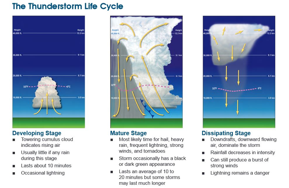
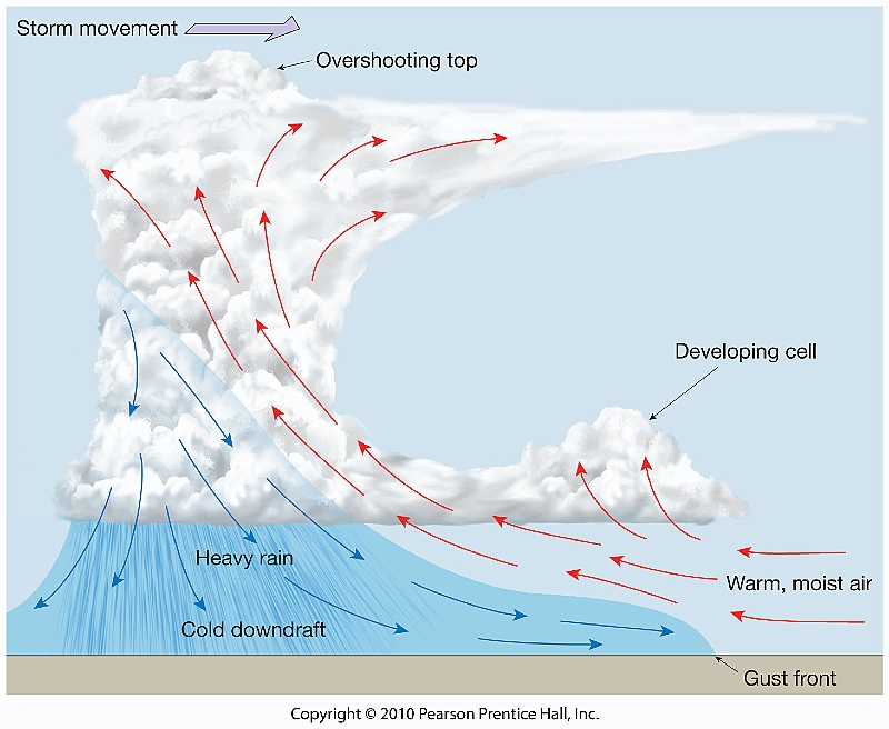
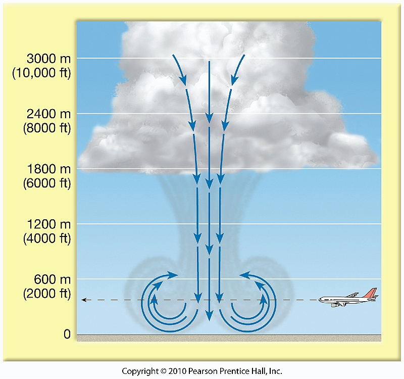
In the United States, air-mass thunderstorms frequently occur in maritime tropical (mT) air that moves northward from the Gulf of Mexico. During the spring and summer, when the air is heated from below by the warmer land surface, the warm, humid air mass becomes unstable and thunderstorms develop. Generally three stages are involved in the development of a thunderstorm. The cumulus stage is dominated by rising currents of air (updrafts) and the formation of a towering cumulonimbus cloud. Falling precipitation within the cloud causes drag on the air and initiates a downdraft that is further aided by the influx of cool, dry air surrounding the cloud, a process termed entrainment. The beginning of the mature stage is marked by the downdraft leaving the base of the cloud and the release of precipitation. With gusty winds, lightning, heavy precipitation, and sometimes hail, the mature stage is the most active period of a thunderstorm. Marking the end of the storm, the dissipating stage is dominated by downdrafts and entrainment. Without a supply of moisture from updrafts, the cloud soon evaporates. It should be noted that within a single air-mass thunderstorm there may be several individual cells, that is, zones of adjacent updrafts and downdrafts.
FOCUS ON HOW THUNDERSTORMS AND TORNADOES FORM.
WHERE DO THEY FORM? - WHERE WOULD YOU FIND STORMS AROUND A MID LATITUDE CYCLONE. WHAT AIR MASS? WHAT FRONT? STAGES OF THUNDERSTORMS.
HOW DO WE FIGURE OUT HOW STRONG THUNDERTORMS AND TORNADOES ARE? WHAT IS A SEVERE THUNDERSTORM? HOW DO WE MEASURE HOW STRONG TORNADO WINDS ARE?
Cumulus Stage: Rising air, or updraft, cools and forms the cloud. The rising air is occurring in an environment that is favorable for convection. Lifting mechanism include solar heating or convergence from a sea breeze. It is not raining during this stage of the thunderstorm.
Mature Stage: As the cloud continues to grow, precipitation particles form and fall from the cloud. The precipitation falls into the updraft. The falling particles drag air down with them. This sinking air is referred to as downdrafts. Entrainment into the downdraft results in some evaporation of the precipitation, which causes a cooling which makes the air more dense, thus increasing the downdraft. Rain begins to reach the surface. Hail may also make it to the surface, but they are not very large.
Dissipating Stage: When the downdrafts encompass the storm, the updrafts
are shut off and the storm begins to die. The intensity of the rain decreases.
CHAPTER 10 PART 1 VIDEO
FOCUS ON HOW THUNDERSTORMS AND TORNADOES FORM.
WHERE DO THEY FORM? - WHERE WOULD YOU FIND STORMS AROUND A MID LATITUDE CYCLONE. WHAT AIR MASS? WHAT FRONT? STAGES OF THUNDERSTORMS.
HOW DO WE FIGURE OUT HOW STRONG THUNDERTORMS AND TORNADOES ARE? WHAT IS A SEVERE THUNDERSTORM? HOW DO WE MEASURE HOW STRONG TORNADO WINDS ARE?
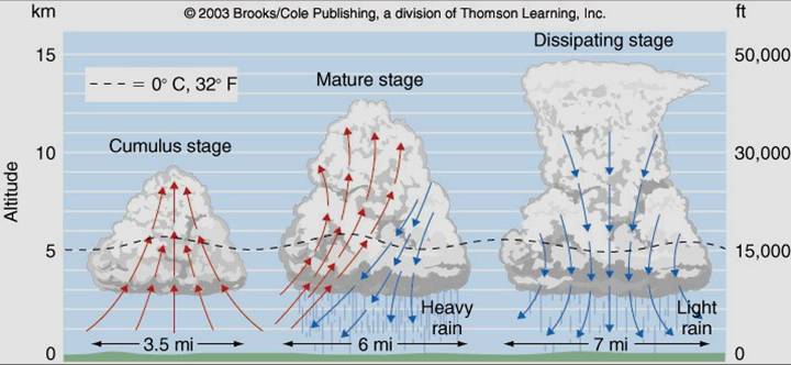
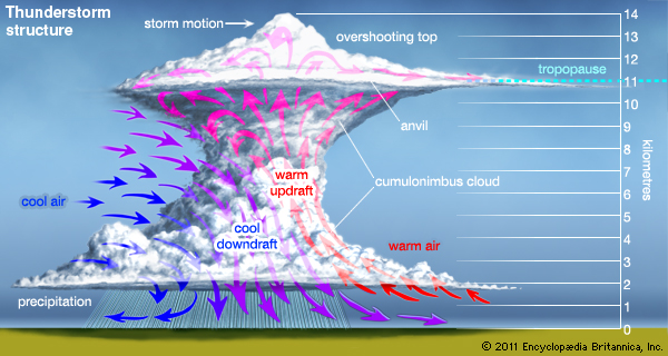
Prior to the development of a thunderstorm, the air near the surface is often warm and moist. With the downdrafts come cool air and the temperature at the surface drops. After the storm passes, the temperature may begin to rise again.
Mountainous regions, such as the Rockies in the West and Appalachians in the East, experience a greater number of air-mass thunderstorms than do the Plains states. Many thunderstorms that form over the eastern two-thirds of the United States occur as part of the general convergence and frontal wedging that accompany passing midlatitude cyclones.
Severe thunderstorms are capable of producing heavy downpours and flash flooding
as well as strong, gusty straight-line winds. Although air-mass thunderstorms
seldom produce severe weather, severe storms are influenced by strong vertical
wind shear, that is, changes in wind direction and/or speed between different
heights, and updrafts that become tilted and continue to build upward. Downdrafts
from the thunderstorm cells reach the surface and spread out to produce an advancing
wedge of cold air, called a gust front, which may form a roll cloud as warm
air is lifted along its leading edge.
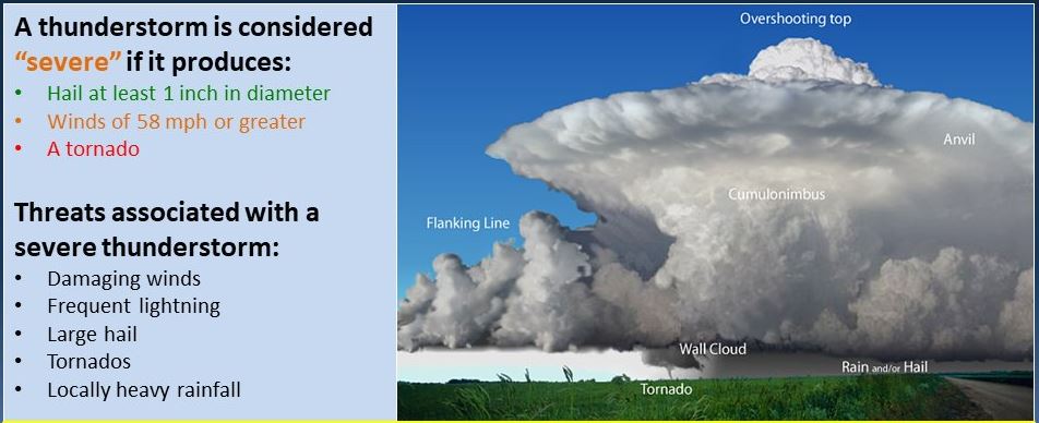
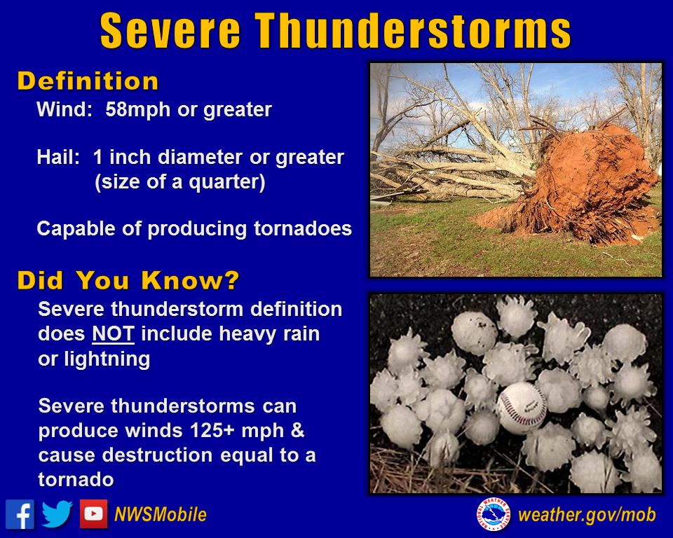
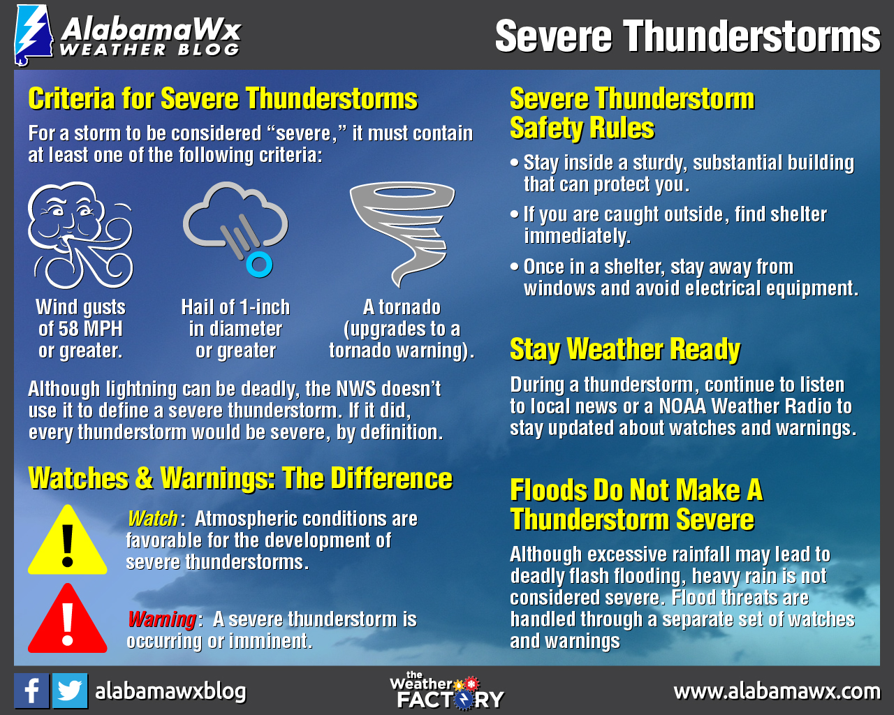
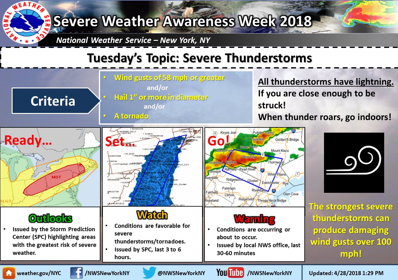
Severe Thunderstorms ---IMPORTANT!!!!!!!!!!!!!!!!!!!!!!!!!!!!!!!!
The National Weather Service defines a severe thunderstorm as
1. having 1-inch
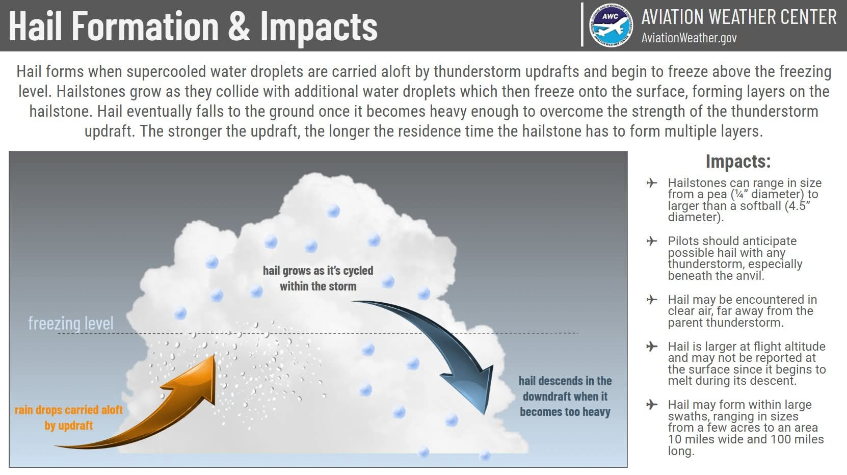
hail or larger - https://www.nssl.noaa.gov/education/svrwx101/hail/
2. surface wind gusts of 50 knots / 58 mph
3. or tornado
https://www.weather.gov/okx/severewxpage - NYC - LONG ISLAND - TRISTATE
SEVERE WEATHER LINKS - Moer about Thunderstorms, Tornadoes and Lightning
https://www.weather.gov/safety/thunderstorm
https://www.nssl.noaa.gov/education/svrwx101/
https://mrcc.illinois.edu/resources/edu_severeWeather.jsp
Severe thunderstorms
--form as warm moist air ahead of a cold front is forced to rise into unstable
air or along squal lines
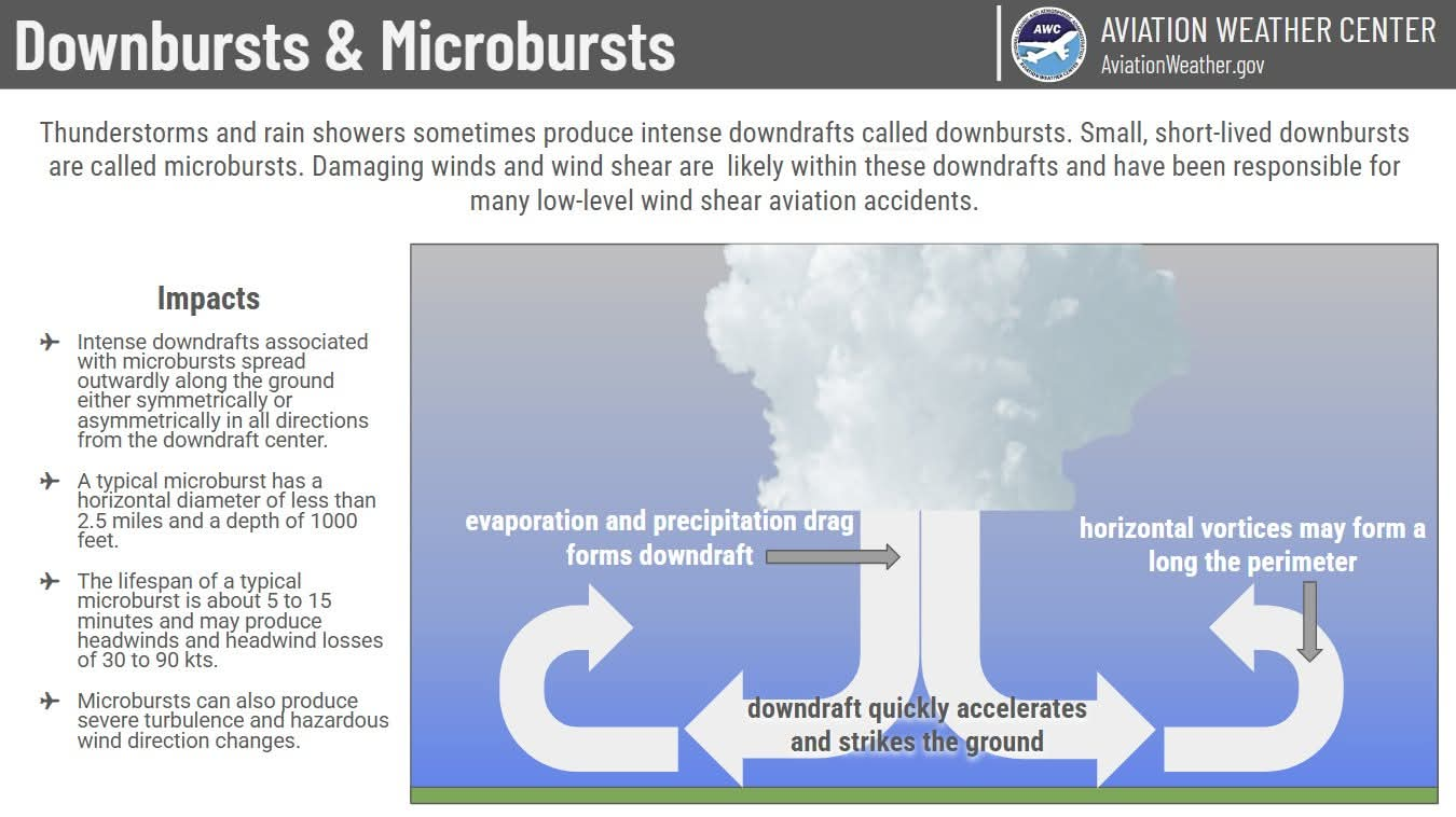
-- micorburts - strong downward winds which can exceed 100 mph
--strong vertical winds may cause the storm to rotate - possible tornado formation
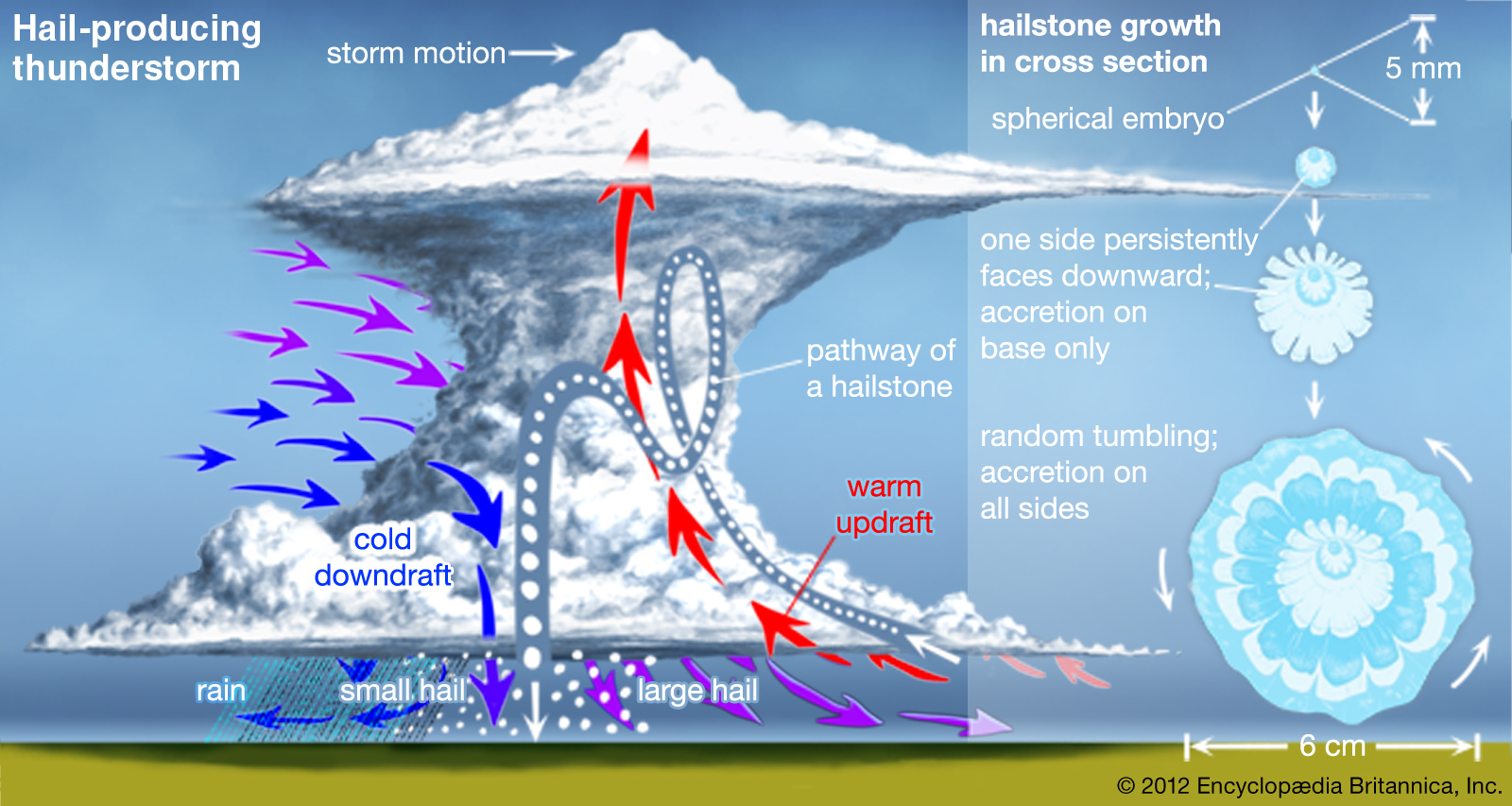
--capable of producing large hail, strong winds, flash floods and tornadoes
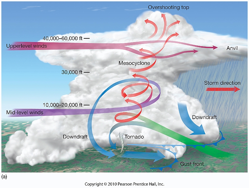
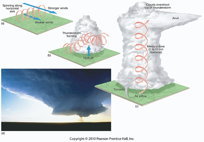
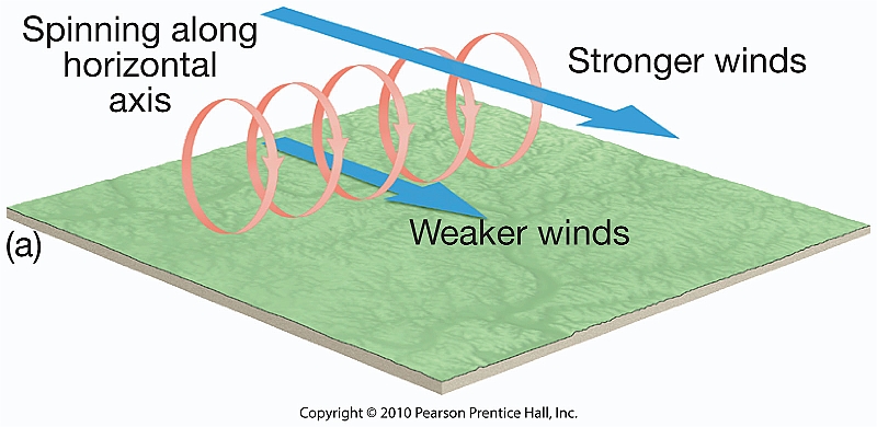
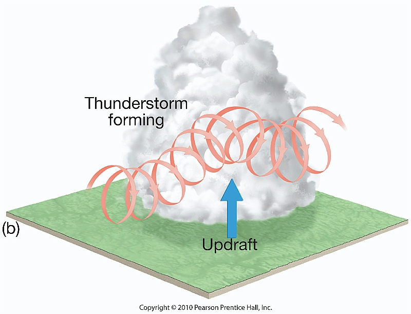
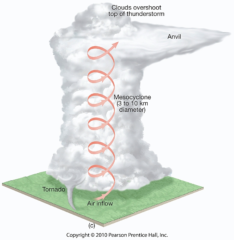
Some of the most dangerous weather is produced by a type of thunderstorm called a supercell, a single, very powerful thunderstorm cell that at times may extend to heights of 20 kilometers (65,000 feet) and persist for many hours. The vertical wind profile of these cells may cause a mesocyclone, a column of cyclonically rotating air, within which tornadoes often form. Supercells appear to form as inversion layers are eroded locally, and unstable air "erupts" from below to form unusually large cumulonimbus clouds with concentrated, persistent updrafts.
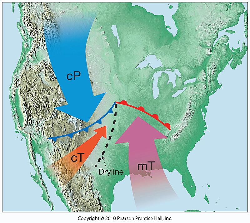
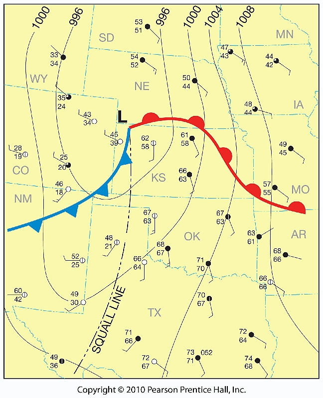
Squall lines are relatively narrow, elongated bands of thunderstorms that develop in the warm sector of a middle-latitude cyclone, usually in advance of a cold front. Some develop when divergence and lifting created by an active jet stream aloft is aligned with a strong, persistent low-level flow of warm, humid air from the north. A squall line with severe thunderstorms can also form along a boundary called a dryline, a narrow zone along which there is an abrupt change in moisture.
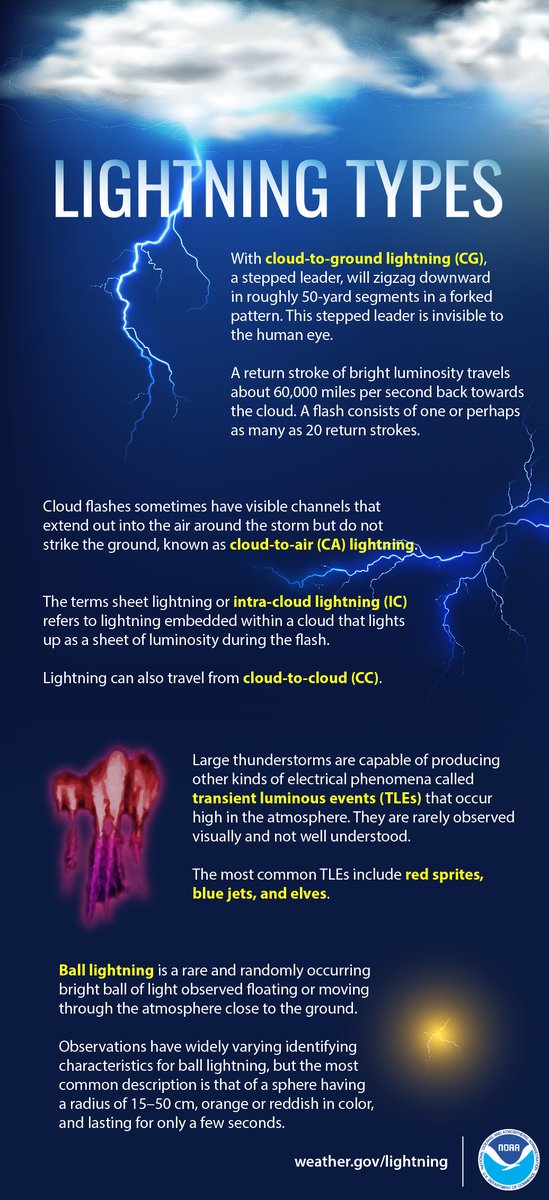
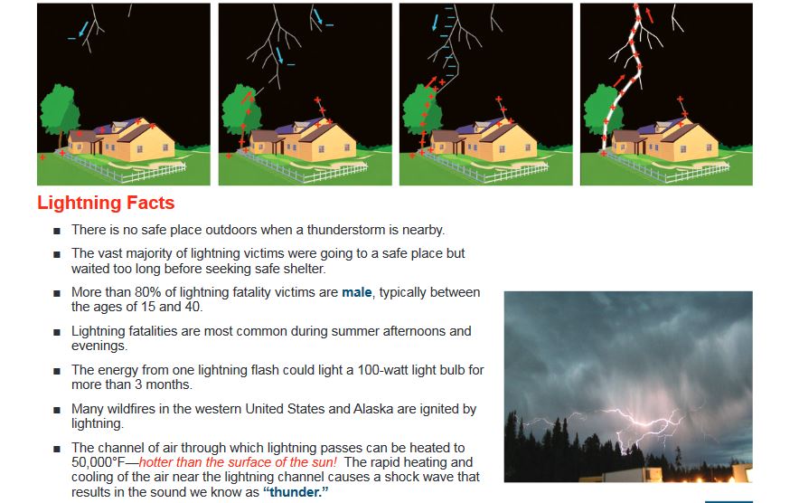
Lightning and Thunder
--rapid discharge (spark) occuring in mature thunderstorms
--within cloud, cloud to cloud, cloud to ground
--lightning stroke heats air to extremely high temperature - air expands explosively
producing a shock wave, thunder
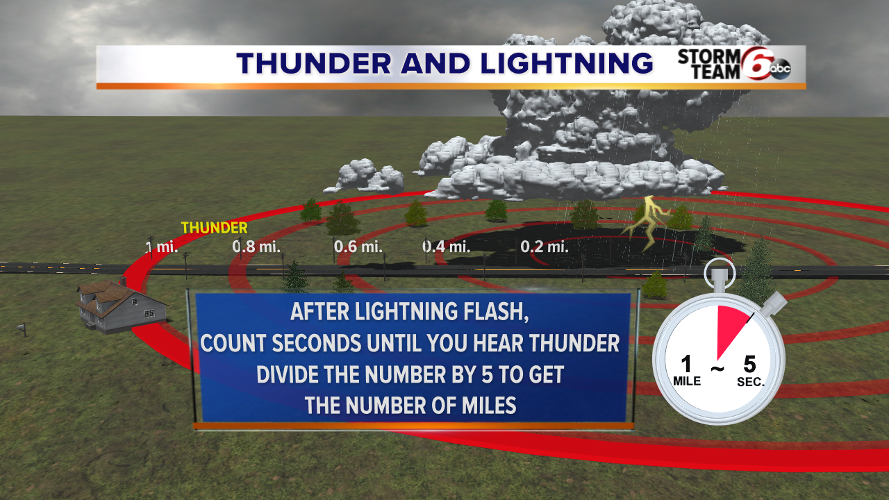
--speed of light = 300,000,000 m/s or 186,000 miles/s;
--speed of sound (thunder) = 340 m/s
VIDEOS ON WHAT CAUSES LIGHTNING
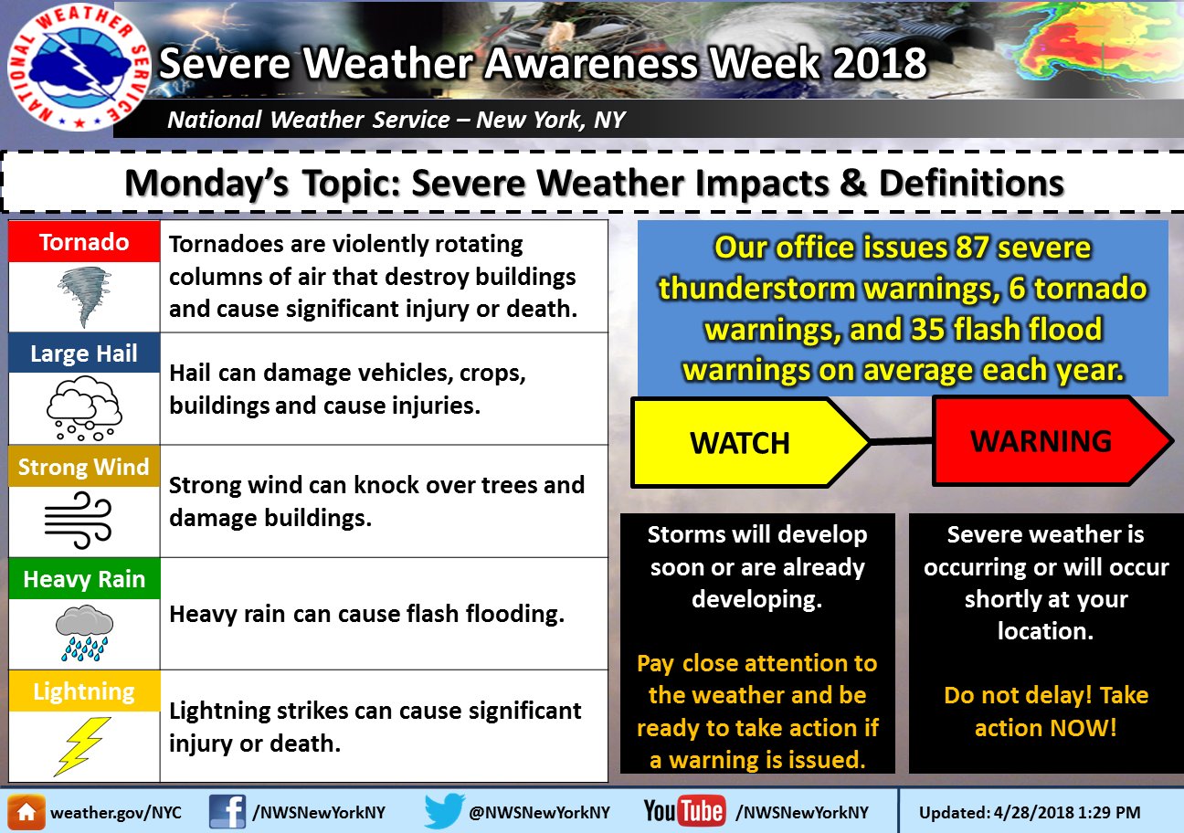
Tornadoes
--local windstorm of short duration
--rotating column of air (vortex) extending down from a cumulonimbus cloud
--low pressure inside
--air near ground rushes inward, spirals upward to cloud
--max winds 300 mph
--spawned along cold fronts
CHAPTER 10 PART 2 VIDEO - TORNADOES
 |
 |
 |
 |
 |
 |
 |
 |
FOCUS ON HOW THUNDERSTORMS AND TORNADOES FORM.
WHERE DO THEY FORM - WHERE WOULD YOU FIND THEM AROUND A MID LATITUDE CYCLONE. WHAT AIR MASS? WHAT FRONT? STAGES OF THUNDERSTORMS.
HOW DO WE FIGURE OUT HOW STRONG THUDNERTORMS AND TORNADOES ARE? WHAT IS A SEVERE THUNDERSTORM? HOW DO WE MEASURE HOW STRONG TORNADO WINDS ARE?
TORNADO FORMATION
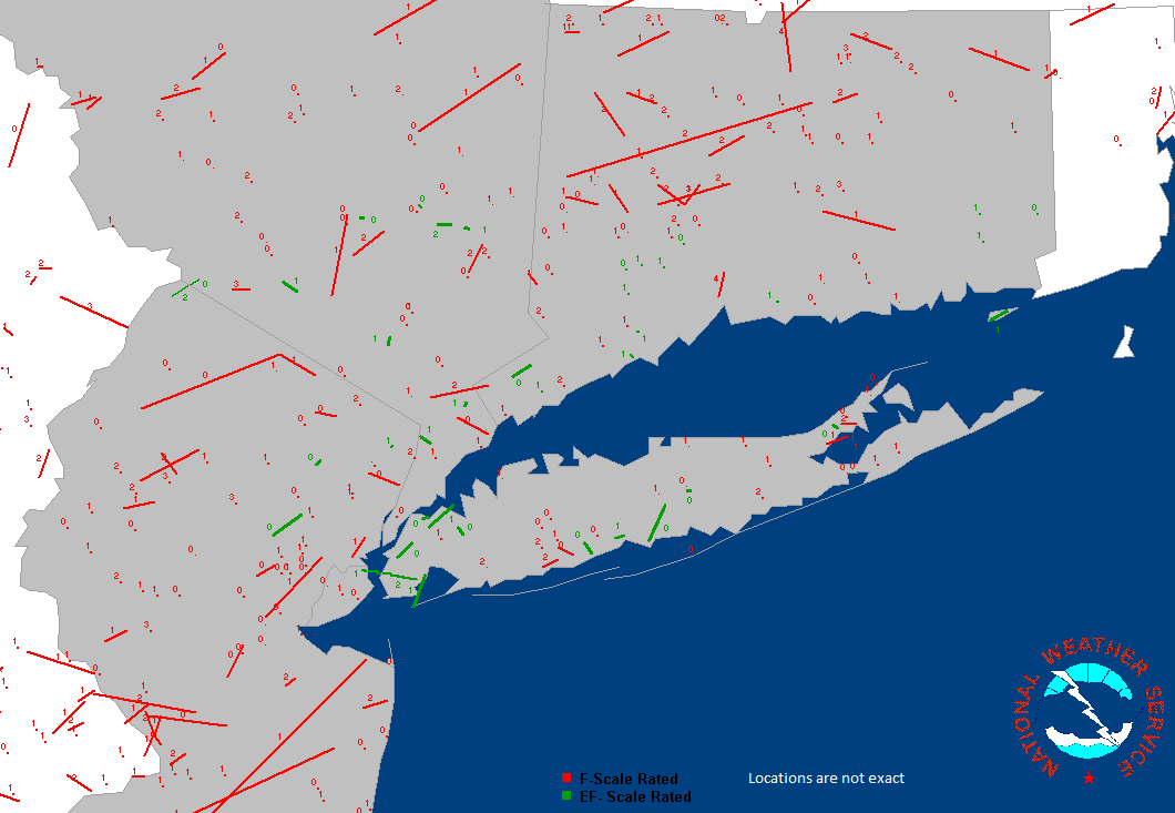
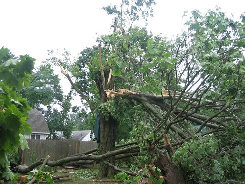
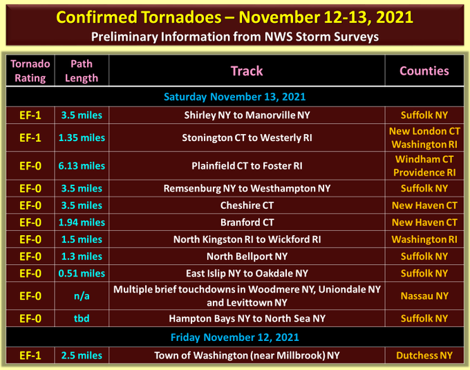
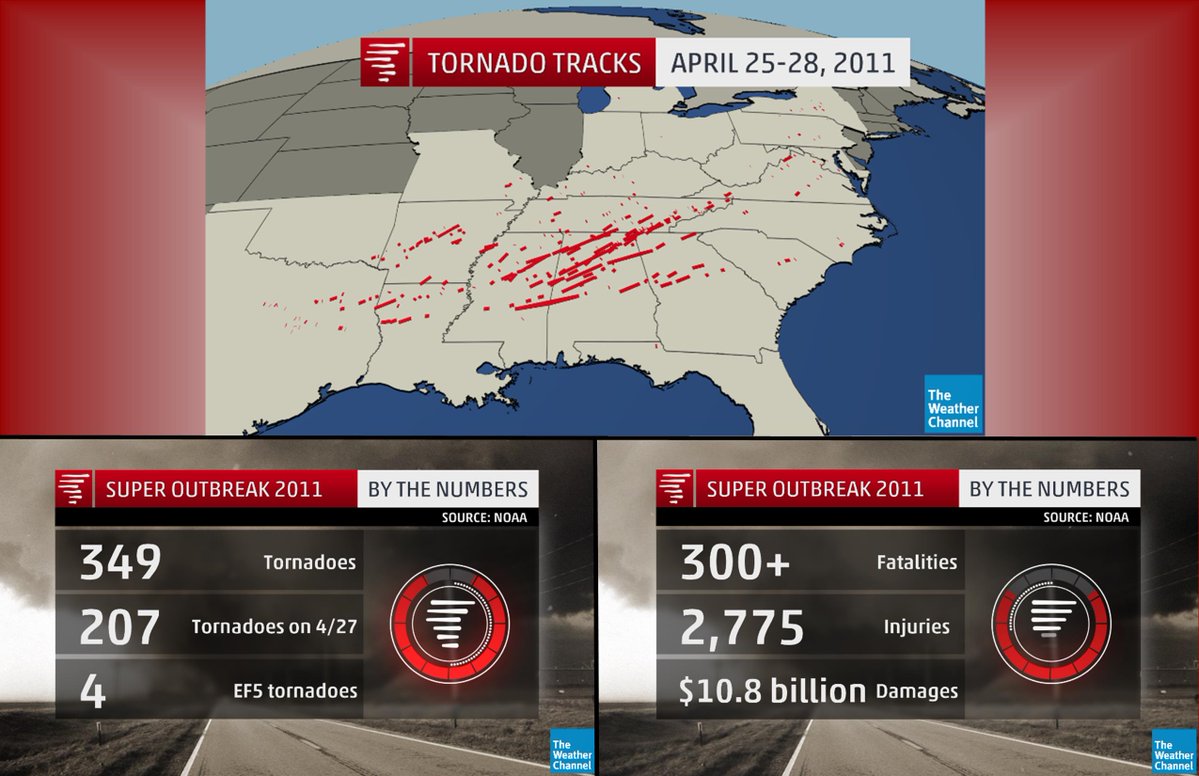
6 tornadoes on long island - NOVEMBER 13TH 2021 -- A RECORD DAY FOR TORNADOES
https://www.weather.gov/okx/AllNov13Tors
There were 11 total tornadoes Saturday - 6 on Long Island New York (plus one Friday in the mid Hudson Valley of NY), 4 in Connecticut and 3 in Rhode Island (2 of the tornadoes crossed from CT into RI).
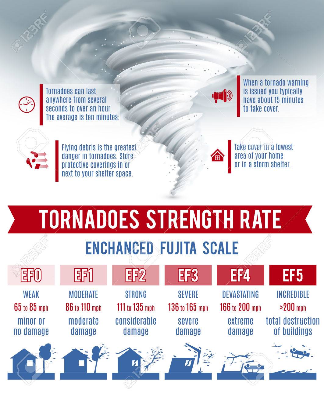
| Enhanced Fujita Scale (EF Scale) |
| National Tornado Frequency |
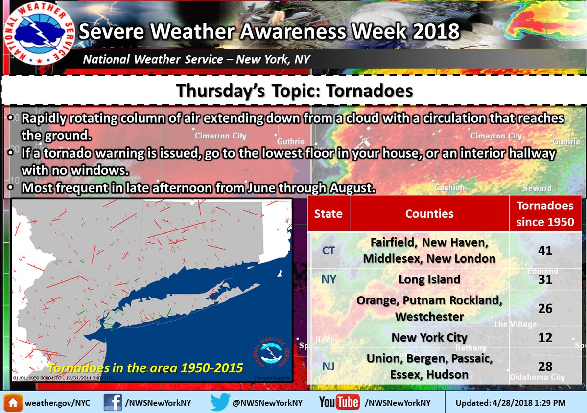
| Local
Tornado Climatology NYC Tristate-NY, NJ,CT |
Notable Statistics for NY, NJ and CT Total Number of Tornado Fatalities (1950-2009) Total Number of Lightning Fatalities (1959-2007)
Enhanced Fujita Scale
Developed in 1971 by Tetsuya "Ted" Fujita (1920 - 1998)
"Mr. Tornado" of the University of Chicago
The Fujita Scale is based on structural strength and engineering research
done by Ted Fujita and a host of others. This research
created the Fujita scale as a measurement of a tornadoes
strength or intensity. Simply put, how intense would a
wind have to be to move a cardboard box or to move
bricks? One questions to ask would be: How fast or intense would the winds have to be
to knock over a brick wall,? Obviously those winds would be significant. Through extensive research the Fujita Scale was developed based on damage, not wind speeds. Based on the extent of this damage conclusions are drawn as to what the winds would likely have to be to cause that type of damage. Since two wooden structured homes can be vastly different in quality and strength, there can be some misleading conclusions from the damage.
Because of this and other overly general conclusions,
storm researchers came up with the Enhanced Fujita scale
to better reflect a tornado’s strength.
Below is the new Enhanced Fujita scale started
February 2007.
| Fujita Scale | Derived EF Scale | Operational EF Scale | ||||
| F Number | Fastest 1/4-mile (mph) | 3 Second Gust (mph) | EF Number | 3 Second Gust (mph) | EF Number | 3 Second Gust (mph) |
| 0 | 40-72 | 45-78 | 0 | 65-85 | 0 | 65-85 |
| 1 | 73-112 | 79-117 | 1 | 86-109 | 1 | 86-110 |
| 2 | 113-157 | 118-161 | 2 | 110-137 | 2 | 111-135 |
| 3 | 158-207 | 162-209 | 3 | 138-167 | 3 | 136-165 |
| 4 | 208-260 | 210-261 | 4 | 168-199 | 4 | 166-200 |
| 5 | 261-318 | 262-317 | 5 | 200-234 | 5 | Over 200 |
| NUMBER (Details Linked) | DAMAGE INDICATOR | ABBREVIATION |
| 1 | Small barns, farm outbuildings | SBO |
| 2 | One- or two-family residences | FR12 |
| 3 | Single-wide mobile home (MHSW) | MHSW |
| 4 | Double-wide mobile home | MHDW |
| 5 | Apt, condo, townhouse (3 stories or less) | ACT |
| 6 | Motel | M |
| 7 | Masonry apt. or motel | MAM |
| 8 | Small retail bldg. (fast food) | SRB |
| 9 | Small professional (doctor office, branch bank) | SPB |
| 10 | Strip mall | SM |
| 11 | Large shopping mall | LSM |
| 12 | Large, isolated ("big box") retail bldg. | LIRB |
| 13 | Automobile showroom | ASR |
| 14 | Automotive service building | ASB |
| 15 | School - 1-story elementary (interior or exterior halls) | ES |
| 16 | School - jr. or sr. high school | JHSH |
| 17 | Low-rise (1-4 story) bldg. | LRB |
| 18 | Mid-rise (5-20 story) bldg. | MRB |
| 19 | High-rise (over 20 stories) | HRB |
| 20 | Institutional bldg. (hospital, govt. or university) | IB |
| 21 | Metal building system | MBS |
| 22 | Service station canopy | SSC |
| 23 | Warehouse (tilt-up walls or heavy timber) | WHB |
| 24 | Transmission line tower | TLT |
| 25 | Free-standing tower | FST |
| 26 | Free standing pole (light, flag, luminary) | FSP |
| 27 | Tree - hardwood | TH |
| 28 | Tree - softwood | TS |
| Intensity Phrase | Type of Tornado ........ | Estimated Wind speeds |
| F0...................Gale tornado.............. winds of 40-70 mph Some damage to chimneys; break branches off trees, pushes over shallow- rooted trees-, damages sign boards. |
| Fl................... Moderate tornado.........winds of 73-112 mph The lower limit is the beginning of hurricane wind speed- peels surface off roofs; mobile homes destroyed. |
| F2...................Significant tornado........winds of 113-157 mph Considerable damage. Roofs torn off frame houses- mobile homes demolished; boxcars pushed over; larger trees snapped or uprooted-, light object missiles generated. |
| F3...................Severe tornado.............winds of 158-206 mph Roof and some wall torn off well constructed houses trains overturned; most trees in forest uprooted |
|
F4...................Devastating tornado........winds of 207-260 mph Well-constructed houses leveled-, structures with weak foundations blown off some distance; cars thrown and large missiles generated. |
| F5..................Incredible tornado...........winds of 261-318 mph Strong frame houses lifted off foundations and carried considerable distances to disintegrate- automobile sized missiles fly in excess of 100 meters; trees debarked; steel reinforced concrete structures badly damaged. |
| F6.................Inconceivable.................winds of 319-379 mph These winds are very unlikely. The small area of damage they might produce would probably not be recognizable along with the mess produced by F4 and F5 wind that would surround the F6 winds. Missiles, such as cars and refrigerators would do serious secondary damage that could not be directly identified as F6 |
A mesoscale convective complex (MCC) consists of many individual thunderstorms that are organized into a large oval to circular cluster. They form most frequently in the Great Plains from groups of afternoon air-mass thunderstorms. Although MCCs sometimes produce severe weather, they also provide a significant portion of the growing-season rainfall to the agricultural regions of the central United States.
Thunder is produced by lightning. The object of lightning is to equalize the electrical difference associated with the formation of a large cumulonimbus cloud by producing a negative flow of current from the region of excess negative charge to the region with excess positive charge, or vice versa. The most comman type of lightning, often called sheet lightning, occurs within and between clouds. The less common but more dangerous type of lightning is cloud-to-ground lightning.
The origin of charge separation in clouds, although not fully understood, must hinge on rapid vertical movements within the cloud. The lightning we see as some single flashes are really several very rapid strokes between the cloud and the ground. When air is heated by the electrical discharge of lightning, it expands explosively and produces the sound waves we hear as thunder. The thunder we hear as a rumble is produced by a long lightning flash at some distance from the observer.
Tornadoes, sometimes called twisters, or cyclones, are violent windstorms that take the form of a rotating column of air, or vortex, that extends downward from a cumulonimbus cloud. Some tornadoes consist of a single vortex. Within many stronger tornadoes, called multiple vortex tornadoes, are smaller intense whirls called suction vortices that rotate within the main vortex. Pressures within some tornadoes have been estimated to be as much as 10 percent lower than immediately outside the storm. Because of the tremendous pressure gradient associated with a strong tornado, maximum winds approach 480 kilometers (300 miles) per hour.
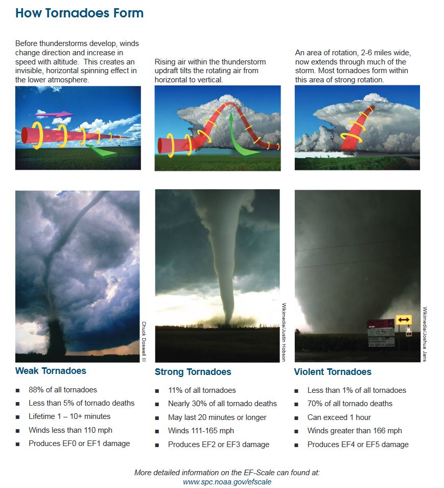
Tornadoes form in association with severe thunderstorms that produce high winds, heavy rainfall, and often damaging hail. They form in any situation that produces severe weather, including cold fronts, squall lines, and tropical cyclones (hurricanes). An important precondition linked to tornado formation in severe thunderstorms is the development of a mesocyclone that forms in the updraft of the thunderstorm. As the narrowing column of rotating air stretches downward, a rapidly spinning funnel cloud may emerge from a slowly rotating wall cloud. If the funnel cloud makes contact with the surface, it is then classified as a tornado.
Severe thunderstorms, and hence tornadoes, are most often spawned along the cold front or squall line of a middle-latitude cyclone or in association with supercell thunderstorms. Although April through June is the period of greatest tornado activity, tornadoes occur during every month of the year. The average tornado has a diameter of between 150 and 600 meters, travels across the landscape toward the northeast at approximately 45 kilometers per hour, and cuts a path about 26 kilometers long.
Most tornado damage is caused by tremendously strong winds. One commonly used guide to tornado intensity is the Fujita Intensity Scale, or simply F-scale.In 2007, changed to the EF-Scale. A rating on the F-scale is determined by assessing the worst damage produced by a storm. Whereas most tornado damage is done by violent winds, most tornado injuries and deaths result from flying debris.
Because severe thunderstorms and tornadoes are small and short-lived phenomena,
they are among the most difficult weather features to forecast precisely. When
necessary, the Storm Prediction Center of the National Weather Service issues
severe thunderstorm outlooks several times daily. When weather conditions favor
the formation of tornadoes, a tornado watch is issued to alert the public to
the possibility of tornadoes over a specified area for a particular time interval.
A tornado warning is issued by local offices of the National Weather Service
when a tornado has been sighted in an area or is indicated by weather radar.
With its ability to detect the movement of precipitation within a cloud, Doppler
radar technology has greatly advanced the accuracy of tornado warning. Using
the principle known as the Doppler effect, Doppler radar can identify the initial
formation and subsequent development of the mesocyclone within a thunderstorm
that frequently precedes tornado development.
NWS New York, NY Outlook, Watch, Warning, and Advisory Definitions
|
|
 Aviation Aviation |
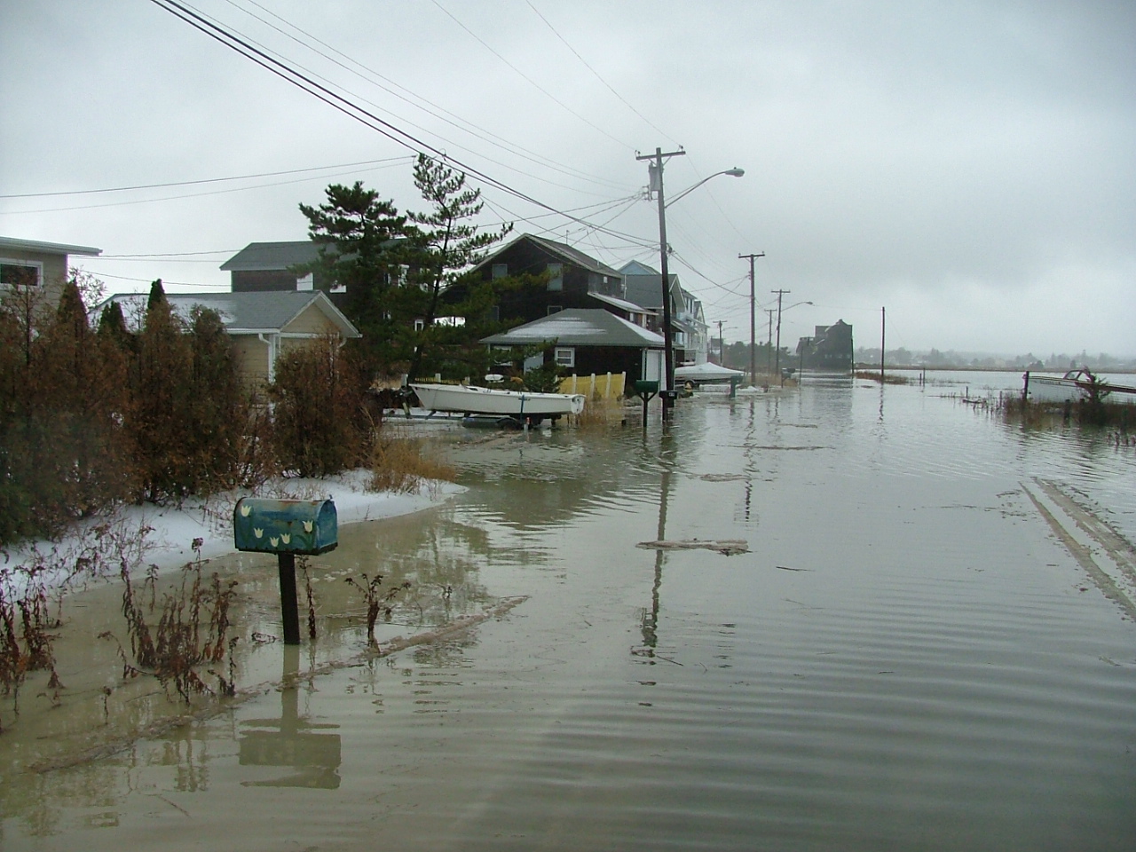 Tides & Coastal Flooding Tides & Coastal Flooding |
|
|
||
|
|
||
|
|
||
|
|
|
|
|
|
|
|
|
 |
 |
 |
 |
|
| Archive
of Significant Weather Events in the Tri-State Area Automated Climate Data, Local Forecasts, Marine Forecasts & Tide Reports are also available 24 hours a day from your local NWS Office at 631-924-0517. |